ES
°F
Cambia tus medidas
Meters
Feet
°C
°F
km/h
mph
kts
am/pm
24-hour
Tu configuración se ha actualizado
Cambia el idioma
Deutsch
Español
Italiano
Nederlands
中文
English
Français
日本語
Português
Hoy dia
7 días
Tiempo
Pesca
Maro
Mareas en
United States
Mareas en
Virginia
Mareas en
Mathews County
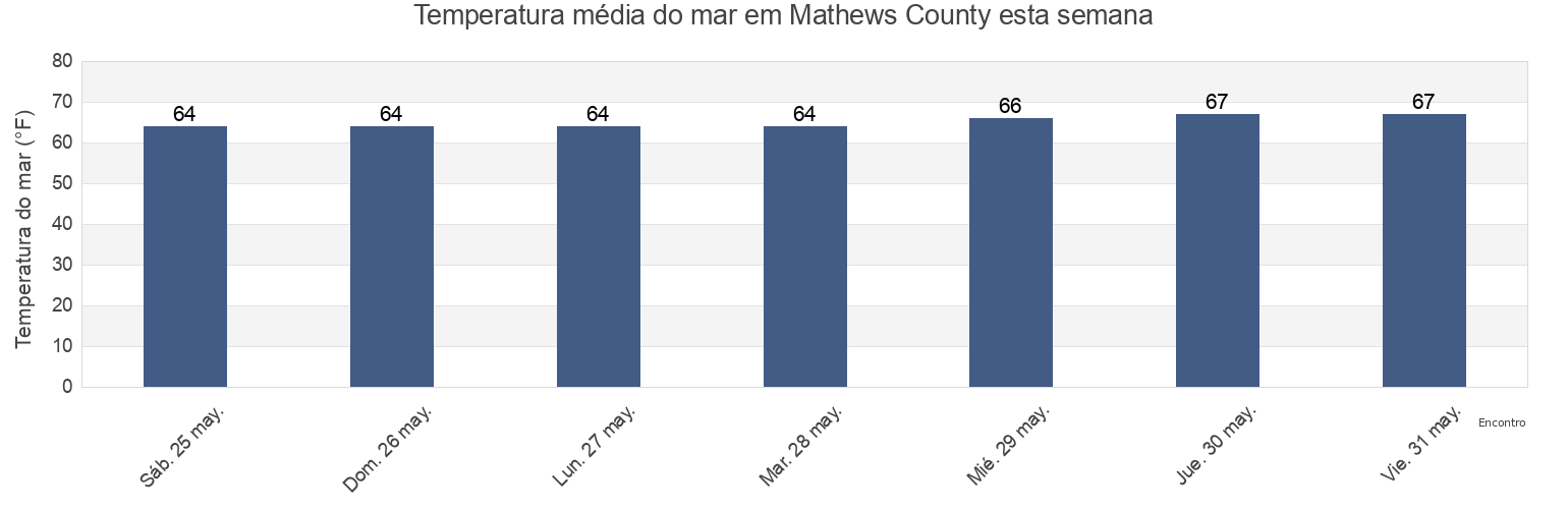
Temperatura del mar en Mathews County
Temperatura del mar en Mathews County para esta semana
Más información sobre mareas y marinas en Mathews County
Mareas para hoy
Mareas esta semana
Tiempo
Tabla de mareas para pesca
Regiones y ciudades de Mathews County, Virginia, United States
Bethel Beach
Little Creek (Railroad Terminal), Chesapeake Bay
Windmill Point Light
Bland Point Piankatank River
Mathews
Windmill Point Light 2.2 n.mi. ESE of
Cherry Point
Mobjack (East River)
Wolf Trap Light
Gwynn Island
Mobjack East River
Wolf Trap Light 0.5 mile west of
Gwynn Island 1.5 n.mi. east of
New Point Comfort 2.0 n.mi. WSW of
Wolf Trap Light 1.4 n.mi. NNE of
Gwynn Island 8.0 n.mi. east of
New Point Comfort 4.1 n.mi. ESE of
Wolf Trap Light 2.0 n.mi. NW of
Mostrar más ubicaciones
Horn Harbor Marina
Stingray Point 1.2 n.mi. NE of
Wolf Trap Light 5.2 n.mi. ENE of
Jackson Creek (Deltaville)
Stingray Point 5.5 miles east of
Jackson Creek Deltaville
SW Branch, Severn River, Mobjack Bay
Tabla de mareas cerca de Mathews County
Bethel Beach
Mathews
Wolf Trap Light 2.0 n.mi. NW of
Horn Harbor Marina
Wolf Trap Light 0.5 mile west of
Wolf Trap Light
Wolf Trap Light 1.4 n.mi. NNE of
Mobjack East River
Mobjack (East River)
Gwynn Island 1.5 n.mi. east of