Mareas para hoy en Charleston County, South Carolina, United States

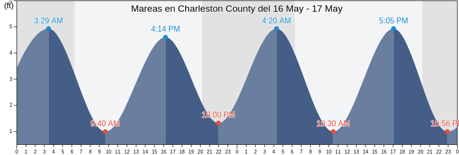
Viernes 26 abril 2024, 20:11 EDT (GMT -0400). La marea está bajando en Charleston County. Como puede ver en la gráficas, la marea más alta de 5.91ft es a las 22:54 y la marea más baja de 0.33ft fue a las 04:33. Haz clic aquí para ver los horarios de mareas de Charleston County para esta semana.

Siguiente marea alta

La próxima marea alta es a las
22:54

Siguiente marea baja

La próxima marea baja es a las
05:14

Tabla de mareas de Charleston County

Tabla de mareas de Charleston County esta semana
Día Tabla de mareas de Charleston County Amanecer y el atardecer
1ra marea 2da marea 3ra marea 4ta marea
vie. 2604:33
0.33 ft
10:24
4.59 ft
16:22
0.33 ft
22:54
5.91 ft
06:37 19:58
sáb. 2705:14
0.66 ft
11:03
4.59 ft
17:01
0.33 ft
23:36
5.91 ft
06:36 19:59
dom. 2806:00
0.66 ft
11:48
4.59 ft
17:47
0.66 ft
06:35 20:00
lun. 2900:26
5.58 ft
06:50
0.66 ft
12:42
4.59 ft
18:41
0.66 ft
06:34 20:00
mar. 3001:24
5.58 ft
07:47
0.66 ft
13:46
4.59 ft
19:46
0.66 ft
06:33 20:01
mié. 102:27
5.58 ft
08:47
0.66 ft
14:55
4.59 ft
20:56
0.66 ft
06:32 20:02
jue. 203:32
5.58 ft
09:49
0.33 ft
16:03
4.92 ft
22:08
0.66 ft
06:31 20:03

Los mejores horarios de pesca para Charleston County hoy Día promedio de pesca

Mejores horarios de pesca

De 09:28 a 11:28

Opuesto al tránsito lunar (Luna abajo)

De 22:00 a 00:00

Tránsito Lunar (Luna arriba)

Decentes horarios de pesca

De 07:30 a 08:30

Puesta de la luna

De 22:30 a 23:30

Salida de la luna

Haga clic aquí para ver los mejores horarios de pesca para Charleston County esta semana.

Clima actual en Charleston County

Parcialmente nublado

Tiempo

Cubierto de nubes 5%
La temperatura

La temperatura

63°F
Min 63°F/Max 69°F
Viento

Viento

15 mph
Ráfaga de viento 18 mph
Humedad

Humedad

75%
Punto de rocío 55°F

Klicken Sie hier, um das Wetter in Charleston County für die Woche zu sehen

El tiempo actual en Charleston County

El sol salió a las 06:37 y el sol se puso a las 19:58. Hoy hubo 13 horas y 21 minutos de sol y la temperatura media es 66°F. En esta momento, la temperatura actual del agua es 63°F. Y la temperatura media del agua es 63°F.

El tiempo en Charleston County hoy
0 h 3 h 6 h 9 h 12 h 15 h 18 h 21 h 24 h
Parcialmente nubladoLluvia irregular en las cercaníasParcialmente nubladoParcialmente nubladoParcialmente nubladoParcialmente nubladoParcialmente nubladoParcialmente nubladoParcialmente nublado
66°F68°F63°F68°F67°F65°F63°F65°F66°F

Klicken Sie hier, um das Wetter in Charleston County für die Woche zu sehen

Más información sobre mareas y marinas en Charleston County

Regiones y ciudades de Charleston County, South Carolina, United States

Abbapoola Creek EntranceFolly River (North Folly Island)Patriots Point
ACE BasinFolly River Bridge (Flooy Island)Pea Island
Army DepotFolly River Bridge Flooy IslandPennys Creek (West Entrance)
Ashley River (I-526 Bridge)Folly River North Folly IslandPennys Creek West Entrance
AwendawFort JohnsonPleasant Point
Battery southwest ofFort SumterPlum Island
Bees Ferry BridgeFort Sumter Range Buoy 14Point Of Pines
Ben Sawyer BridgeFort Sumter Range Buoy 2Price Creek (North Capers Island)
Ben Sawyer Bridge ICWWFort Sumter Range Buoy 20Price Creek North Capers Island
Big Paradise IslandFort Sumter Range Buoy 4Rathall Creek entrance
Bluff PointFort Sumter Range Buoy 8Rebellion Reach 0.8 n.mi. N. of Ft. Sumter
Botany Bay IslandFt. Sumter 0.6 n.mi. NW ofRemley Point 0.2 mile northwest of
Bowen IslandGoose Creek entranceRockville (Bohicket Creek)
Breach Inlet (Isle Of Palms)Goshen Point SE of Wadmalaw RiverRockville Bohicket Creek
Breach Inlet Isle Of PalmsGoshen Point south of Wadmalaw RiverS.C.L. RR. bridge 0.1 mile below
Buck Hall (Awendaw Creek)Hamlin Creek (Isle Of Palms)S.C.L. RR. bridge 1.5 miles above
Buck Hall Awendaw CreekHamlin SoundSandblasters (Pennys Creek)
Buoy '19'Harbor River EntranceSandblasters Pennys Creek
Buoy 19 off Nowell CreekHo-non-wah Boy Scout Camp (Bohicket Creek)Seabrook Beach
CainhoyHobcaw PointSeabrook Island
Cainhoy Wando RiverHog Island ChannelSecessionville Secessionville Creek
Capers Creek South Capers IslandHog Island Reach Buoy 12Shem Creek
Castle Pinckney 0.4 mile south ofHog Island Reach SW of Remley PointShipyard Creek (0.8 mile above entrance)
Castle Pinckney 0.6 mile southwest ofHollywoodShipyard Creek entrance
CharlestonHorlbeck Creek 0.2 mile above entranceShutes Folly Island 0.4 mile west of
Charleston (customhouse Wharf)Horlbeck Creek 2.5 miles north ofShutes Reach Buoy 8
Charleston Harbor (off Fort Sumter)Horse ReachSnake Island
Charleston Harbor EntranceI 526 BridgeSol Legare Island
Charleston Hbr. ent. (between jetties)Isle of PalmsSouth Ashley Bridge
Church Creek BridgeIsle Of Palms PierSouth Capers Island
Church FlatsJack Creek EntranceSouth Chan. 0.4 mi. NW of Ft. Johnson
Clouter Creek (North Entrance)James Island Creek (1 mi. above ent.)South Chan. 0.8 mi. ENE of Ft. Johnson
Clouter Creek (South Entrance)Johns Island (Church Creek)South Channel Buoy 32
Clouter Creek North EntranceJohns Island Airport south ofSouth Dewees Island (Dewees Inlet)
Clouter Creek South EntranceJohns Island BridgeSouth Dewees Island Dewees Inlet
Cosgrove BridgeJohns Island Church CreekSouth Jetty break in
Customhouse ReachKiawah IslandState Hwy. 7 bridge
Customhouse Reach off CustomhouseKiawah River BridgeStono Inlet
Daniel Island BendLeadenwah Creek (3 Mi. Above Entrance)Sullivans I. 0.7 mi. NE of Ft. Sumter
Daniel Island ReachLimehouse BridgeSullivans Island
Daniel Island Reach Buoy 48MeggettSullivans Island (outer Coast)
Deveaux Banks off North Edisto River entranceMoores Landing (Sewee Bay)The Cove (Fort Moultrie)
Drayton Bees FerryMoores Landing ICWW Sewee BayThe Cove entrance on the Cove Range
Drum Island 0.2 mile aboveMorris IslandThe Cove Fort Moultrie
Drum Island 0.4 mile SSE ofMount PleasantThe Washout
Drum Island east of (bridge)North CharlestonTown Creek 0.2 mile above bridge
Drum Island Reach off Drum I. Buoy 45North Dewees Island (Capers Inlet)Town Creek Lower Reach
Duck IslandNorth Dewees Island Capers InletWadmalaw Island Wadmalaw River entrance
Elliott Cut EntranceNorth Edisto River entranceWando River Upper Reach Turning Basin
Elliott Cut west endNorth Jetty 0.8 mile southeast ofWappoo Creek
Filbin Creek ReachNowell CreekWappoo Creek Highway Bridge
Filbin Creek Reach 0.2 mile east ofNowell Creek entranceWappoo Creek off of
Filbin Creek Reach Buoy 58Oak Branch (Bohicket Creek)West Marsh Island 0.1 mile east of
Five Fathom Creek EntranceOak Branch Bohicket CreekWharf Creek Entrance
Folly BeachOcella Creek (2 Mi. Above Entrance)Woods Point
Folly Beach PierOld Capers Landing (Capers Island)Woods Point SE of
Folly Creek (Hwy. 171 Bridge)Old Capers Landing Santee Pass Capers IslandWoodville
Folly I. Channel N of Ft. JohnsonOrdnance ReachYellow House Creek
Folly Island (outer Coast)Parker Island (Horlbeck Creek)Yellow House Landing 1 mile NW of
Folly Reach Buoy 5Parker Island Horlbeck CreekYonges Island