ES
°F
Cambia tus medidas
Meters
Feet
°C
°F
km/h
mph
kts
am/pm
24-hour
Tu configuración se ha actualizado
Cambia el idioma
Deutsch
Español
Italiano
Nederlands
中文
English
Français
日本語
Português
Hoy dia
7 días
Tiempo
Pesca
Maro
Mareas en
United States
Mareas en
Rhode Island
Mareas en
Washington County
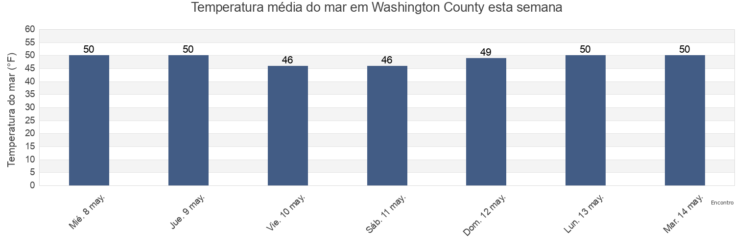
Temperatura del mar en Washington County
Temperatura del mar en Washington County para esta semana
Más información sobre mareas y marinas en Washington County
Mareas para hoy
Mareas esta semana
Tiempo
Tabla de mareas para pesca
Regiones y ciudades de Washington County, Rhode Island, United States
2.4 miles southwest of
Lake Montauk
Point Judith Harbor Of Refuge
4 miles north of
Lewis Point 6.0 miles WNW of
Pond entrance - Point Judith
Allen Harbor
Lewis Pt. 1.0 mile southwest of
Quonochontaug Beach
Ashaway
Lewis Pt. 1.5 miles west of
Quonochontaug Beach 1.1 miles S of
Atlantic Terrace
Lighthouse (Point Judith)
Quonochontaug Beach 3.8 miles S of
Block Island (Great Salt Pond)
Little Narragansett Bay entrance
Richmond Island
Mostrar más ubicaciones
Block Island (Old Harbor)
Mansion Beach
Roger Wheeler State Beach
Block Island (SW end), Block Island Sound
Matunuck-Deep Hole
Salty Brine State Beach
Block Island (West)
Matunuck-The point
Sandy Point 2.1 miles NNE of
Block Island East (New Shoreham)
Misquamicut State Beach
Sandy Point 4.1 miles northwest of
Bradford
Monahans Dock
Sandy Pt. 1.5 miles north of
Cerberus Shoal 1.5 miles east of
Montauk
Scarborough State Beach
Charlestown
Montauk Harbor Entrance
Shagwong Reef & Cerberus Shoal
Charlestown Breachway Beach
Montauk Point - Turtles
Southwest Ledge
Clay Head 1.2 miles ENE of
Montauk Point 1 mile northeast of
Southwest Ledge 2.0 miles west of
Crescent Beach
Montauk Point 1.2 miles east of
Southwest Point Block Island
East Beach Ninigret Conservation Area
Montauk Point 5.4 miles NNE of
Stonington
East Matunuck State Beach
Moonstone Beach
Wakefield-Peacedale
East Pt. 4.1 miles S of Fishers Island
Napatree Jetty
Watch Hill Point
Exeter
Napatree Point 0.7 mile southwest of
Watch Hill Point 2.2 miles east of
Fortress
Narragansett Beach
Watch Hill Point 5.2 miles SSE of
Galilee Beach Club Beach
Narragansett Pier
Watch Hill Point 5.3 n.mi. SE of
Great Salt Pond ent. 1 mile NW of
Narragansett Town Beach
Weekapaug Point (Block Island Sound)
Great Salt Pond entrance
North Bar
Weekapaug Point Block Island Sound
Green Hill Point 1.1 miles south of
North Kingstown
Westerly
Harbor of Refuge south entrance
North Kingstown Beach
Westerly (Pawcatuck River)
Hopkinton
North Pier (Narragansett)
Westerly Pawcatuck River
K38/39
Old Harbor Pt. 0.5 mile southeast of
Wicopesset island NE of
Kingston
Point Judith (Harbor Of Refuge)
Tabla de mareas cerca de Washington County
Charlestown Breachway Beach
Charlestown
East Beach Ninigret Conservation Area
Green Hill Point 1.1 miles south of
Moonstone Beach
Matunuck-Deep Hole
East Matunuck State Beach
Pond entrance - Point Judith
Matunuck-The point
Salty Brine State Beach