ES
°F
Cambia tus medidas
Meters
Feet
°C
°F
km/h
mph
kts
am/pm
24-hour
Tu configuración se ha actualizado
Cambia el idioma
Deutsch
Español
Italiano
Nederlands
中文
English
Français
日本語
Português
Hoy dia
7 días
Tiempo
Pesca
Maro
Mareas en
United States
Mareas en
New York
Mareas en
Kings County
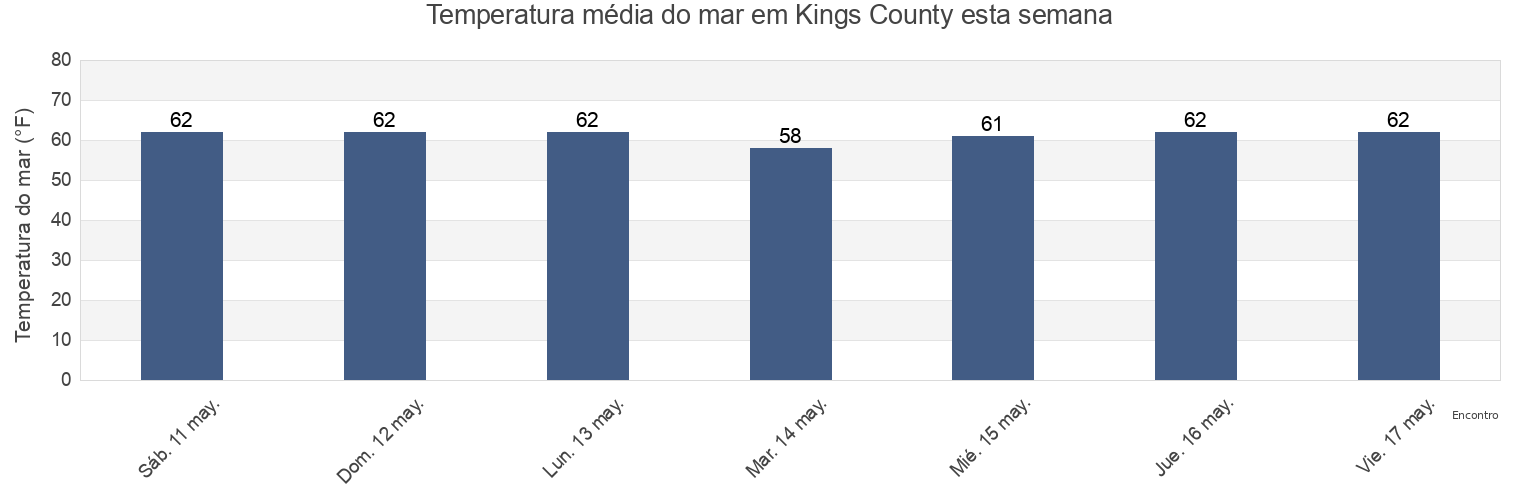
Temperatura del mar en Kings County
Temperatura del mar en Kings County para esta semana
Más información sobre mareas y marinas en Kings County
Mareas para hoy
Mareas esta semana
Tiempo
Tabla de mareas para pesca
Regiones y ciudades de Kings County, New York, United States
13th Street
Canarsie (midchannel off pier)
Norton Point
15th Street
Coney Island
Norton Point (Gravesend Bay)
17th Ave
Coney Island Brooklyn
Norton Point Gravesend Bay
40th Street
Dead Horse Bay
Plum Beach Brooklyn
64th Place
East New York
Plumb Beach Channel
Barren Island (Rockaway Inlet)
English Kills entrance
Red Hook Channel
Mostrar más ubicaciones
Barren Island east of
Fort Tilden Queens
Rockaway Beach
Barren Island Rockaway Inlet
Governors Island
Rockaway Beach Queens
Bay Ridge Channel
Gowanus Bay
Rockaway Inlet entrance
Beach Channel (bridge)
Grassy Bay (bridge)
Rockaway Inlet Jetty 1 mile SW of
Bee Hives
Guacuco
Rockaway Point
Bensonhurst
Jacob Riis Park Queens
Sandbox
Brighton Beach Brooklyn
Manhattan Beach Brooklyn
Sheepshead Bay
Brooklyn
Manhattan Bridge East of
Wallabout Bay
Brooklyn Bridge
Mill Basin
Wallabout Bay Brooklyn Navy Yard
Brooklyn Bridge 0.1 mile southwest of
North 3rd Street
Williamsburg Bridge
Buttermilk Channel
North Channel Bridge (Grassy Bay)
Williamsburg Bridge 0.3 mile north of
Canarsie
North Channel Bridge Grassy Bay
Tabla de mareas cerca de Kings County
Brooklyn
40th Street
Mill Basin
17th Ave
Plum Beach Brooklyn
15th Street
13th Street
Bensonhurst
Canarsie (midchannel off pier)
Canarsie