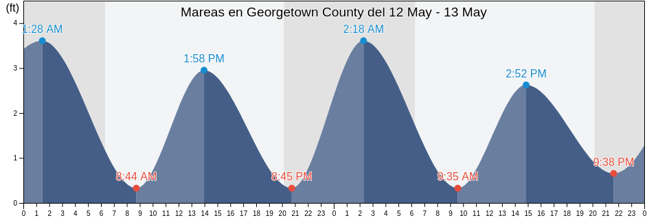
Mareas para hoy en Georgetown County, South Carolina, United States

Martes 16 abril 2024, 05:32 EDT (GMT -0400). La marea está bajando en Georgetown County. . Como puede ver en la gráfica, la marea más alta de 3.28ft fue a las 04:43 y la marea más baja de 0.66ft es a las 12:02. Haz clic aquí para ver los horarios de mareas de Georgetown County para esta semana.

Siguiente marea alta

La próxima marea alta es a las
17:21

Siguiente marea baja

La próxima marea baja es a las
12:02

Tabla de mareas de Georgetown County

Tabla de mareas de Georgetown County esta semana
Día Tabla de mareas de Georgetown County Amanecer y el atardecer
1ra marea 2da marea 3ra marea 4ta marea
mar. 1604:43
3.28 ft
12:02
0.66 ft
17:21
2.62 ft
06:45 19:49
mié. 1700:12
0.66 ft
05:41
3.28 ft
12:59
0.66 ft
18:18
2.95 ft
06:44 19:50
jue. 1801:12
0.66 ft
06:35
3.28 ft
13:50
0.66 ft
19:10
2.95 ft
06:42 19:51
vie. 1902:07
0.66 ft
07:24
3.28 ft
14:35
0.33 ft
19:57
3.28 ft
06:41 19:51
sáb. 2002:56
0.33 ft
08:09
3.28 ft
15:17
0.33 ft
20:39
3.28 ft
06:40 19:52
dom. 2103:42
0.33 ft
08:50
3.28 ft
15:56
0.33 ft
21:18
3.61 ft
06:39 19:53
lun. 2204:25
0.33 ft
09:28
3.28 ft
16:33
0.33 ft
21:55
3.61 ft
06:38 19:54

Los mejores horarios de pesca para Georgetown County hoy Día promedio de pesca

Mejores horarios de pesca

De 12:17 a 14:17

Tránsito Lunar (Luna arriba)

Decentes horarios de pesca

De 02:41 a 03:41

Puesta de la luna

De 12:47 a 13:47

Salida de la luna

Haga clic aquí para ver los mejores horarios de pesca para Georgetown County esta semana.

Clima actual en Georgetown County

Parcialmente nublado

Tiempo

Cubierto de nubes 5%
La temperatura

La temperatura

73°F
Min 63°F/Max 78°F
Viento

Viento

9 mph
Ráfaga de viento 18 mph
Humedad

Humedad

86%
Punto de rocío 59°F

Klicken Sie hier, um das Wetter in Georgetown County für die Woche zu sehen
El tiempo actual en Georgetown County

El sol saldrá a las 06:45 y la puesta del sol será a las 19:49. Habrá 13 horas y 04 minutos de sol y la temperatura media es 71°F. En esta momento, la temperatura actual del agua es 64°F. Y la temperatura media del agua es 64°F.

El tiempo en Georgetown County hoy
0 h 3 h 6 h 9 h 12 h 15 h 18 h 21 h 24 h
Despejado/SoleadoParcialmente nubladoParcialmente nubladoSoleadoParcialmente nubladoParcialmente nubladoParcialmente nubladoParcialmente nubladoParcialmente nublado
65°F73°F69°F73°F77°F73°F69°F66°F65°F

Klicken Sie hier, um das Wetter in Georgetown County für die Woche zu sehen

Más información sobre mareas y marinas en Georgetown County

Regiones y ciudades de Georgetown County, South Carolina, United States

Allston CreekGarden City Pier (ocean)Oyster Landing (N. Inlet Estuary)
Arundel PlantationGeorgetownOyster Landing Crab Haul Creek North Inlet
Bennet's DockGeorgetown LighthousePawleys Island
Bennets Dock Pawleys Island CreekGeorgetown Sampit RiverPawleys Island Pier (ocean)
Black River (south Of Dunbar)Hagley LandingPee Dee River swing bridge
Brown Island (South Santee River)Holly Grove PlantationPleasant Hill Landing (Santee River)
Brown Island South Santee RiverJacobs WharfPleasant Hill Landing Santee River
BucksportLafayette swing bridge Waccamaw RiverRabbit Island northwest of
Bull Creek EntranceLitchfield BeachRange D off Mosquito Creek
Butler Island 0.3 mile south ofLitchfield Beach BridgeSampit River entrance
Cape RomainLittle Bull Creek Entrance (Bull Creek)Smith's Dock
Cape Romain (46 Miles East Of)Little Bull Creek Entrance Bull CreekSouth Island Ferry (Intracoastal Waterway)
Cape Romain 46 Miles East OfLower Topsaw LandingSouth Island Plantation
Captain Alex's MarinaMagnolia BeachSouth Of Sam Worth Game Management Area
Captain Alexs Marina Parsonage CreekMc Clellanville Jeremy CreekSouth Santee River (Highway 17 Bridge)
Carr Creek (1 mile above entrance)Mcclellanville (Jeremy Creek)South Santee River entrance
Carr Creek 1 Mile Above EntranceMcClellanville Jeremy CreekThe Pier (Pawleys Island)
Casino CreekMidway Inlet North (Pawleys Island)Thoroughfare Creek Entrance
Casino Creek ICWWMidway Inlet North Pawleys IslandU S Highway 17 Bridge South Santee River
Cedar Island (North Santee Bay)Minim Creek Entrance (North Santee Bay)U.S. Highway 17 Bridge South Santee River
Cedar Island North Santee BayMt Pleasant Plantation Black RiverWaccamaw River Entrance
Cedar Island Point (South Santee River)Mt. Pleasant Plantation (Black River)Wachesaw Landing
Cedar Island Point South Santee RiverMt. Pleasant Plantation Black RiverWard's Dock
Clambank Creek (North Inlet)Murrells InletWards Dock Pawleys Inlet
Clambank Creek Goat Island North InletNorth SanteeWeymouth Plantation
Divine's DockNorth Santee BridgeWindsor Plantation (Black River)
Frazier PointNorth Santee River entranceWindsor Plantation Black River
Frazier Point south ofNorth Santee River InletWinea Plantation (Black River)
Frazier Point west ofOaks Creek (0.5 Mi. Above Entrance)Winea Plantation Black River
Garden City Bridge (Main Creek)Oaks Creek (Upper End)Winyah Bay Entrance (south Jetty)
Garden City Bridge Main CreekOceanside BeachYauhannah Bridge