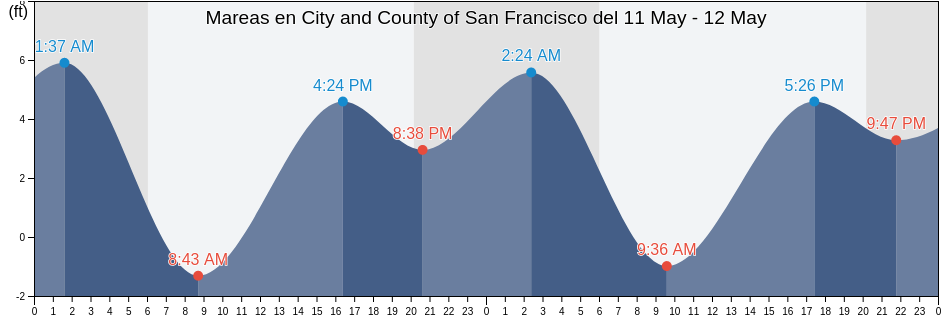
Tabla de mareas de City and County of San Francisco hoy

Mareas para hoy en City and County of San Francisco, California, United States

Martes 19 marzo 2024, 00:15 PDT (GMT -0700). La marea está bajando en City and County of San Francisco. Como puede ver en la gráficas, la marea más alta de 5.25ft es a las 07:55 y la marea más baja de 0ft es a las 15:11. Haz clic aquí para ver los horarios de mareas de City and County of San Francisco para esta semana.

Siguiente marea alta

La próxima marea alta es a las
07:55

Siguiente marea baja

La próxima marea baja es a las
02:18

Tabla de mareas de City and County of San Francisco

Tabla de mareas de City and County of San Francisco esta semana
Día Tabla de mareas de City and County of San Francisco Amanecer y el atardecer
1ra marea 2da marea 3ra marea 4ta marea
mar. 1902:18
2.95 ft
07:55
5.25 ft
15:11
0 ft
22:27
4.92 ft
07:14 19:22
mié. 2003:17
2.62 ft
08:59
5.25 ft
15:57
0 ft
23:01
4.92 ft
07:12 19:23
jue. 2104:04
2.3 ft
09:53
5.25 ft
16:34
0 ft
23:29
4.92 ft
07:11 19:24
vie. 2204:44
1.97 ft
10:39
5.25 ft
17:05
0.33 ft
23:54
5.25 ft
07:09 19:24
sáb. 2305:20
1.64 ft
11:21
5.25 ft
17:33
0.66 ft
07:08 19:25
dom. 2400:15
5.25 ft
05:53
1.31 ft
12:01
5.25 ft
17:59
0.66 ft
07:06 19:26
lun. 2500:34
5.25 ft
06:25
0.98 ft
12:40
4.92 ft
18:25
0.98 ft
07:05 19:27

Los mejores horarios de pesca para City and County of San Francisco hoy Día promedio de pesca

Mejores horarios de pesca

De 00:40 a 02:40

Opuesto al tránsito lunar (Luna abajo)

De 13:11 a 15:11

Tránsito Lunar (Luna arriba)

Decentes horarios de pesca

De 04:14 a 05:14

Puesta de la luna

De 13:41 a 14:41

Salida de la luna

Haga clic aquí para ver los mejores horarios de pesca para City and County of San Francisco esta semana.

Clima actual en City and County of San Francisco

Tiempo

Cubierto de nubes 28%
La temperatura

La temperatura

53°F
Min 47°F/Max 55°F
Viento

Viento

7 mph
Ráfaga de viento 11 mph
Humedad

Humedad

90%
Punto de rocío 50°F

Klicken Sie hier, um das Wetter in City and County of San Francisco für die Woche zu sehen

El tiempo actual en City and County of San Francisco

El sol saldrá a las 07:14 y la puesta del sol será a las 19:22. Habrá 12 horas y 08 minutos de sol y la temperatura media es 51°F. En esta momento, la temperatura actual del agua es 56°F. Y la temperatura media del agua es 56°F.

El tiempo en City and County of San Francisco hoy
0 h 3 h 6 h 9 h 12 h 15 h 18 h 21 h 24 h
SoleadoSoleado
53°F54°F47°F54°F52°F51°F47°F52°F52°F

Klicken Sie hier, um das Wetter in City and County of San Francisco für die Woche zu sehen

Más información sobre mareas y marinas en City and County of San Francisco

Regiones y ciudades de City and County of San Francisco, California, United States

2nd StreetNorth Point Pier 35 north ofPoint San Pablo midchannel
Alameda Estuary southeast endNorthridge ParkPoint San Pedro
Alameda Naval Air StationOakland (Matson Wharf)Point San Pedro 0.55 nmi. SE of
Alameda Radar Tower 0.9 nmi. SSW ofOakland 7th St. Marine 0.6 nmi. SSW ofPoint San Quentin
Alcatraz (North Point)Oakland AirportPoint San Quentin 0.82 nmi. east of
Alcatraz IslandOakland Airport southwest ofPoint San Quentin 1.3 nmi. east of
Alcatraz Island .8 mi EOakland Airport SWPoint San Quentin 1.9 mi E
Alcatraz Island 0.2 mile west ofOakland Berth 67Point San Quentin 1.9 miles east of
Alcatraz Island 0.5 mile north ofOakland Harbor (Grove Street)Point Simpson Angel I. 1.05 nmi. E of
Alcatraz Island south ofOakland Harbor (Park Street Bridge)Potrero Point
Alcatraz Island southwest ofOakland Harbor Grove StreetPotrero Point 1.08 nmi. east of
Alcatraz Island WOakland Harbor High Street BridgePotrero Point 1.1 mi E
Angel Island .8 mi EOakland Harbor Park Street BridgePotrero Point 2 miles east of
Angel Island (East Garrison)Oakland Harbor Webster StreetPt. Blunt Angel I. 0.25 nmi. east of
Angel Island (west Side)Oakland Harbor WebStreeter StreetPt. Blunt Angel I. 0.8 mi. SE of
Angel Island 0.75 mile east ofOakland Inner HarborRaccoon Strait
Angel Island East GarrisonOakland Inner Harbor ChannelRaccoon Strait off Hospital Cove
Angel Island off Quarry PointOakland Inner Harbor ReachRaccoon Strait off Point Stuart
Aquatic ParkOakland Matson WharfRed Rock .1 E
Baker BeachOakland Middle HarborRed Rock 0.60 nmi. NNE of
Baker Beach (South Bay) 0.3 nmi. NW ofOakland Outer Harbor Entrance LB 3Red Rock east of
Baker s BeachOakland PierRichardson Bay Entrance
Bay Bridge Pier DOakland Yerba Buena IslandRichmond Inner Harbor
Bay Bridge Span B-COcean BeachRincon Point
Berkeley Yacht HarborOcean Beach (Outer Coast)Rincon Point midbay
Berkeley Yacht Harbor .9 mi SOcean Beach Outer CoastRoberts Landing (1.3 Miles West Of)
BlackiesOyster Point 2.8 miles east ofRoberts Landing 1.3 Miles West Of
Bluff Point .1 mi EOyster Point MarinaRockaway Beach
Bluff Point 0.1 mile east ofPacifica State BeachSachuest Beach (2nd Beach)
Bluff Point 1.15 nmi. east ofPalisades ParkSan Francisco
Brooklyn BasinPier 23San Francisco (Golden Gate)
Candlestick PointPinole PointSan Francisco (North Point Pier 41)
Carquinez Bridge I-80Pinole Point 1.18 nmi. west ofSan Francisco Bar
Chevron Oil Company Pier RichmondPinole Point 1.2 mi WSan Francisco Bar north of ship channel
China BeachPinole Point 1.27 nmi. NNW ofSan Francisco Bay Entrance (Golden Gate)
Corte Madera CreekPinole Point 1.42 nmi. NNW ofSan Francisco Bay Entrance (Outside)
Coyote Point 2.3 nmi. NNE ofPinole Point 3.0 nmi. WNW ofSan Francisco North Point Pier 41
Crown Memorial State BeachPinole Point San Pablo BaySan Francisco southern traffic lane N end
Davis Point (midchannel)Pinole ShoalSan Francisco traffic separation zone buoy
Davis Point 1.0 nmi. NW ofPoint AdamsSan Leandro Channel
Emeryville MarinaPoint Avisadero .3 mi ESan Leandro Channel (San Leandro Bay)
Fleming Point 1.7 mi SWPoint Avisadero 0.3 mile east ofSan Leandro Channel San Leandro Bay
Fleming Point 1.72 nmi. SW ofPoint Avisadero 0.6 nmi. ESE ofSan Leandro Marina
Fort Cronkite Rodeo BeachPoint Avisadero 1 mi ESausalito
Fort Funston BeachPoint Avisadero 1 mile east ofSausalito (Corps Of Engineers Dock)
Fort Point 0.3 nmi. west ofPoint Avisadero 1.25 nmi. SSE ofSausalito Corps Of Engineers Dock
Fort Point 0.5 nmi. east ofPoint Avisadero 2 mi ESeaplane Harbor
Golden Gate Bridge .8 mi E .Point Avisadero 2 miles east ofSelby
Golden Gate Bridge 0.46 nm E ofPoint Blunt .3 mi SSharp Park
Golden Gate Bridge 0.8 mile east ofPoint Blunt .8 mi SESierra Point 1.2 nmi. east of
Golden Gate Bridge 0.88 nm NE ofPoint Blunt Angel I. 0.25 mile S ofSierra Point 1.3 mi ENE
Golden Gate East BeachPoint Blunt Angel I. 0.5 nmi. SW ofSierra Point 1.3 miles ENE of
HerculesPoint Bonita (Bonita Cove)Sierra Point 4.4 mi E
Hercules (Refugio Landing)Point Bonita 0.8 nmi. NE ofSierra Point 4.4 miles east of
Hercules Refugio LandingPoint Bonita 0.95 nm SSE ofSouth Bay
Hunters PointPoint Bonita Bonita CoveSouth Channel
Hunters Point 1.6nm SE ofPoint Bonita Lt. 0.4 nmi. SSE ofSouthampton Shoal Channel LB 6
Jap RockPoint Bonita Lt. 5.27 nmi. WSW ofSouthampton Shoal Light .2 mi E
Lands End BeachPoint Cavallo 1.3 mi ESouthampton Shoal Light 0.2 mile E of
Leconte BayPoint Cavallo 1.3 miles east ofThe Strait
Little Coyote Pt 3.4 mi NNEPoint ChaunceyTreasure Island .3 mi E
Little Coyote Pt. 3.4 nmi. NNE ofPoint Chauncey 0.75 nmi. NW ofTreasure Island .5 mi N
Long View ParkPoint Chauncey 1.25 nm north ofTreasure Island 0.2 mile west of
Mare IslandPoint Chauncey 1.3 miles east ofTreasure Island 0.3 mile east of
Mare Island Strait (Buoy 4)Point Diablo 0.2 mile SE ofTreasure Island 0.5 mile north of
Mare Island Strait EntrancePoint IsabelTreasure Island 0.78 NM NW of
Mare Island Strait NE of Pier 34Point LobosTreasure Island 0.8 mile west of
Marin CountyPoint Lobos 1.3 nmi. SW ofTreasure Island 0.85 nmi. east of
Mile Rock beachPoint Lobos 3.73 nmi. W ofWilson Point 3.9 mi NNW
Mile Rock Lt. 0.2 nmi. NW ofPoint Lobos 5.47 nmi. SW ofWilson Point 3.90 nmi. NNW of
Mission Rock 0.6 mile east ofPoint OrientYellow Bluff .8 mi E
Mission Rock 1.3 mile east ofPoint PinoleYellow Bluff 0.8 mile east of
Mission Rock 2.0 miles east ofPoint Richmond .5 mi WYerba Buena Island
Mount Tamalpais State ParkPoint Richmond 0.5 mile west ofYerba Buena Island 0.3 nmi. SE of
Mulford Gardens Channel ApproachPoint Richmond 0.8 nmi. NNW ofYerba Buena Island W of
Mussel Rock ParkPoint San BrunoYerba Buena Island west of (midchannel)
North PointPoint San Bruno 0.51 nmi. east of